A Thousand Kilometers Of Intent Every metro line planned for Sài Gòn – and what is actually being built

Sài Gòn has 19.7 kilometers of metro. One line, 14 stations, opened December 2024. The plan on the table calls for a little over a 1,000 kilometers.
That gap is not a typo, and it is not quite the scandal it looks like either. It is what happens when a city spends 17 years learning how to build a subway, finally builds one, and then has the legal handbrake released on everything else at once.
Anyone who has ever played a city builder knows the exact feeling: you spend an hour drawing the whole network – every line, every interchange, the loop you are proud of – and then you unpause and find out how long a 1,000 kilometers actually takes at normal speed. Sài Gòn unpaused somewhere around December 2025. There has been a metro announcement almost every week since.
So: where this actually stands, as of the end of July 2026. What is running, what is being dug, what has money attached, and what is still a colored line on a planning map. I have tried to be honest about which is which, because most of what gets published on this – especially in English – is not.
Where it stands today
Line 1, Bến Thành to Suối Tiên. 19.7 kilometers, of which 2.6 run underground through the center and 17.1 on viaduct. 14 stations, three of them below ground. Long Bình depot, 20.56 hectares. Just over 43,000 billion VNĐ of Japanese ODA, delivered by Shimizu-Maeda, Sumitomo, Hitachi and Nippon Koei, on 1,435 mm standard gauge – which is not what Vietnam’s national railway runs on, and that decision will matter for the next 40 years.
It opened on 22 December 2024, 17 years after approval and roughly 12 years after the first shovel.
The numbers since then are the single best argument the whole program has: in its first year the line ran 78,194 services and carried about 18.95 million passengers, which is 114 percent of what was forecast. Daily average around 52,000. Peak days above 110,000. Over half a million people rode it during the seven days of Tết Bính Ngọ in February, 42 percent above plan, with extra services laid on between 00:30 and 02:00 so people could get home after the fireworks.
Fares run 7,000 to 20,000 VNĐ. Since March there has been a combined bus and metro pass – 47,000 VNĐ for a day, 412,000 for a month, half that for students.
What those numbers do not capture is how quickly the thing stopped being an attraction. The first weeks were queues around Bến Thành and people filming the doors. Now it is students asleep against the glass, office workers with iced coffee sweating onto the floor, and somebody’s grandmother taking the whole length of it to Suối Tiên because the air conditioning is free and the seats are cold. That transition took about four months.
One asterisk, and it is a good one to hold onto for later: the project’s formal construction completion was quietly pushed to the fourth quarter of 2026, a year late, for defect remediation and warranty work. The line has been carrying 50,000 people a day for 19 months and is, on paper, still under construction.
What changed
Three documents, in 11 months.
Resolution 188, passed by the National Assembly in February 2025, is the one that actually did the work. It lets Hà Nội and Sài Gòn skip the investment-policy approval stage entirely and go straight to project approval, appoint contractors directly instead of running international tenders, write their own technical standards, and borrow more flexibly. Dry stuff. The effect is not dry at all. By the city’s own accounting: skipping the policy-approval step saves at least three to five years per project. Direct appointment of the Line 2 consultants saved six to eight months. Rescheduling Line 1 without a fresh appraisal saved another three to six.
Three to five years. Per project. That is the entire explanation for everything below.
Resolution 202, in June 2025, redrew the map instead. Bình Dương and Bà Rịa-Vũng Tàu were dissolved into Ho Chi Minh City with effect from 1 July 2025. The city tripled in area and inherited two provincial rail plans it had not written.
Then Resolution 09, signed for the Politburo by Tô Lâm in May 2026, set the target that everyone is now sprinting at: roughly 200 kilometers of metro operating by 2030, network essentially complete by 2045.
200 kilometers by 2030 means finishing more than 180 kilometers in under four years, in a city that needed two decades for its first 20. Thanh Niên, which is not a hostile newspaper, called it very nearly an impossible task. Hold that thought too.
The thousand kilometers, correctly labeled
You will see the figure quoted as 1,012 km, 1,024 km, or 1,045 km depending on which agency published last. All three refer to the same thing: 27 lines across the post-merger city.
The split is the part nobody mentions:
- Former Ho Chi Minh City
12 lines, 582 km - Former Bình Dương
12 lines, 305 km - Former Bà Rịa-Vũng Tàu
3 lines, 125 km
So a bit under 60 percent of the famous 1,000 is the metro a visitor would recognize as Sài Gòn’s. The rest is provincial network – inherited, real, planned by other people, and now sitting inside the same city limits.
Which is worth saying plainly, because the reflex is to call this a borderless megaregion knitting itself together. It is not quite that. The borders moved first, in a single National Assembly vote, and the rail network is being retrofitted to the new shape afterward. One city, three legacy planning authorities, three sets of drawings that were merged on paper before anyone reconciled them.
The tell is beautiful and slightly absurd: the merged network currently has two Line 1s, two Line 2s and two Line 3s. The Hồ Chí Minh City Institute for Development Studies has been running a public survey – it closes today, 31 July – asking residents whether lines should be numbered, colored, named end to end, or some combination, and what a station name should prioritize: brevity, pronounceability for foreigners, historic place names, proximity to a hospital or a university. A city crowdsourcing the legend of a map it has not built yet – I find that genuinely charming and I filled it in.
There is one thing that is properly cross-border, and it is the most interesting corridor on the whole map: the projects running east into Đồng Nai, toward the new Long Thành airport. Two provinces, two governments, and a deadline set by an airport – which is why they are being pushed through under emergency-works rules rather than normal procedure. More on those below.
The staged targets, which disagree with each other
MAUR, the city’s urban rail board, presented one set in August 2025: Lines 1 through 7 by 2035 – 355 km, about 40.21 billion USD, covering 40 to 50 percent of all trips. Lines 8, 9 and 10 by 2045 – another 155 km, about 17.95 billion USD.
The Department of Construction has been quoting a different set through 2026: about 187 km by 2030, 14 lines and 462 km by 2035, 19 lines and 700 km by 2045.
Both are current. Neither is wrong. They are measuring slightly different things, which is a useful thing to know before you quote either at a dinner party.
The network, line by line
The Sài Gòn core – 12 lines, 582 km
- Line 1 – An Hạ to Suối Tiên
The operating segment, Bến Thành to Suối Tiên, is the 19.7 km above. Extensions west to An Hạ and east into Đồng Nai are separate projects. - Line 2 – Thủ Thiêm to Củ Chi
Over 60 km in three segments. Two are under construction, the Củ Chi leg is not. - Line 3 – An Hạ to Hiệp Bình Phước
45.8 km. On the priority list, no start date. - Line 4 – Đông Thạnh to Hiệp Phước
47.3 km, running through Tân Sơn Nhất and Bến Thành. The second airport line, and the one that would serve the south of the city properly. - Line 5 – Đa Phước to Long Trường
Planned, unfunded. - Line 6 – inner ring
53.8 km all the way around. Phase 1 is funded and starting this year – see below. - Line 7 – Tân Kiên to Long Bình
In the 2035 tranche. - Line 8 – Bình Mỹ to Đa Phước
2045 tranche. - Line 9 – Tam Bình to An Hạ
2045 tranche. - Line 10 – outer ring
2045 tranche. The outer orbital, and the one I would bet against seeing. - Line 11 – Sài Gòn river LRT
The odd one out: light rail, following the river. No timeline. - Line 12 – Cần Giờ
Now the VinSpeed high-speed line. Under construction, sort of. See below.
The Bình Dương network – 12 lines, 305 km
Two of these are funded and starting this year: Line 1, new city center of Bình Dương down to Suối Tiên, and Line 2, Thủ Dầu Một into central Sài Gòn. Both connect the northern industrial belt directly into the existing network, and both matter enormously to anyone commuting to a factory.
The other ten are route reservations. Real corridors, drawn by planners who knew what they were doing, with no funded timeline attached: Line 1b (Tân Đông Hiệp to Gò Dưa), Line 2b (Thủ Dầu Một to Bến Cát), Line 2c (Thủ Dầu Một to Củ Chi), Line 3 in two segments around Tân Uyên, Line 4 (Tân Uyên to Bến Cát), Line 5 (Bắc Tân Uyên to Bến Cát), Line 6 (new city to Bàu Bàng), Line 7 (Bến Cát to Dầu Tiếng), Line 8 (Bắc Tân Uyên to Phú Giáo).
Read them as a shape rather than a list and they make sense: a northern reach toward Bàu Bàng and Dầu Tiếng, and an eastern industrial belt looping around Tân Uyên. That is a rail plan for a manufacturing region, folded into a city plan by an administrative decision, and it explains a good chunk of the thousand-kilometer headline.
The Vũng Tàu network – 3 lines, 125 km
- Line 1
A 20 km loop around inner Vũng Tàu. - Line 2
65 km down the coast: Vũng Tàu, Long Hải, Phước Hải, Bình Châu. - Line 3
40 km inland, Vũng Tàu to Bà Rịa to Phú Mỹ – and being studied for extension to Long Thành airport, which would make it the one line in this group with a national-scale job.
Coastal, tourist-facing, and a long way from funded.
The Đồng Nai corridor – the genuinely cross-border bit
Two projects, both aimed at Long Thành airport, both being run at emergency speed because the airport is not waiting. Tuổi Trẻ counts five projects across three corridors aimed at linking Tân Sơn Nhất to Long Thành, roughly 368,800 billion VNĐ between them – about 14.2 billion USD.
Status board
Running
Line 1, Bến Thành to Suối Tiên. Everything in the first section.
Under construction
- Line 2, Bến Thành to Tham Lương
11.3 km, over 9 of them bored, 11 stations, around 55,000 billion VNĐ of straight public money, driverless. Started 15 January 2026. The first diaphragm-wall cage went into the ground at Phạm Văn Bạch station on 2 July 2026. That station and Lê Thị Riêng are the two tunnel-boring launch shafts, which is why they went first. The TBMs go down around August 2027. Target completion 2030. This line was originally supposed to be carrying passengers this year. - Line 2, Bến Thành to Thủ Thiêm
6.2 km, every meter of it underground, six stations, about 36,700 billion VNĐ as a public-private BT contract with Đại Quang Minh, a THACO company. Started 29 April 2026. It runs under Hàm Nghi, bores beneath the Sài Gòn river and surfaces along Mai Chí Thọ. Hàm Nghi station sits 33 meters down, the deepest in the city. Full GoA4 automation – no driver, no attendant. THACO is building a 320-hectare rail industry complex here with Hyundai Rotem to assemble carbodies domestically, which is the part of this project with the longest shadow. - Bến Thành to Cần Giờ
Around 54 km, double track, 1,435 mm, designed for 350 km/h – intercity high-speed standards applied to a city corridor, which is either visionary or slightly mad depending on the day. Over 102,000 billion VNĐ, roughly 4 billion USD, entirely private, built and owned by VinSpeed under a build-own-operate contract. Phạm Nhật Vượng holds 51 percent of it. Phase 1 has exactly two stations – Bến Thành and Cần Giờ – and does the run in about 16 minutes. Phase 2 would add Tân Thuận, Tân Mỹ, Nhà Bè and Bình Khánh. Target operation 2028.
That last one needs a caveat. Vietnamese distinguishes between động thổ, a ceremonial ground-breaking, and khởi công, the actual start of construction. Cần Giờ had its động thổ on 19 December 2025. The feasibility study is due for approval this quarter, formal construction start is scheduled for the fourth quarter of 2026, and land handover is targeted for November. English-language coverage collapses both words into “broke ground”, which is how you end up with a completely wrong picture of the timeline.
Approved, ground-breaking promised before December
The city has told the Ministry of Construction it will start four projects totaling 138.8 kilometers before the end of this year.
- Thủ Thiêm to Long Thành
47.7 km, of which 11.5 sit in Sài Gòn and 36.2 in Đồng Nai. 19 stations, 17 of them elevated. Around 175,000 billion VNĐ, roughly 7 billion USD – it was quoted at 157,405 billion in March, which tells you how firm these numbers are. Start September 2026, finish 2030. - Line 6 phase 1, Tân Sơn Nhất to Phú Hữu
22.85 km, about 19 of them bored, 17 stations, depot at Bình Triệu, 86,529 billion VNĐ. Approval November, start December, completion December 2030. This is the newest piece on the board and the one to watch. - Bình Dương Line 1, new city center to Suối Tiên
32.8 km all on viaduct, 19 stations, Phú Chánh depot, around 55,000 billion VNĐ. Approval November, start December, completion 2030. - Bình Dương Line 2, Thủ Dầu Một to Tao Đàn
Grew from 21.87 km to about 35 during planning – 20 elevated, 15 underground, 24 stations. Approval November, start December, completion end of 2030.
Line 6 deserves a paragraph of its own: it links Bà Quẹo, where it meets Line 2, through all three Tân Sơn Nhất terminals, across the city to Phú Hữu in Thủ Đức, where it joins the Thủ Thiêm to Long Thành line. Connect those and you get a single rail spine from the old airport to the new one. On 26 July, MAUR proposed bending the alignment: shifting Bà Quẹo station 245 meters north for a cleaner interchange, and dropping station ST03 between terminals T1 and T2 – because the approved route left passengers a 100-meter walk to the doors. Public consultation is open right now. Survey rigs are already drilling along Phạm Văn Đồng.
Proposed, in procedure
- Line 1 east to Long Thành airport
Suối Tiên to the new Đồng Nai administrative center to the airport. Between 41.4 and 44.6 km depending on the version, around 60,000 billion VNĐ, public-private with land plots as counter-payment, Đồng Nai in charge. On 30 July 2026 – yesterday, as I write this – the government agreed in principle to build it under emergency-works rules. Land clearance is meant to be finished by 31 December. - Line 1 west to An Hạ
On the priority list, no date. - Line 3, Hiệp Bình Phước to An Hạ
45.8 km, priority list, no date. - Line 4, Đông Thạnh to Hiệp Phước
47.3 km, priority list, no date. - Line 2 north, Tham Lương to Củ Chi
24 stations, priority list, no date. - Vũng Tàu Line 3 extended to Long Thành
Under study.
The city’s 2026 to 2030 investment-attraction list names nine metro lines and more than 981,000 billion VNĐ of capital it would like someone to bring. Its formal budget request is 221,098 billion from the central government plus 123,996 billion of its own money, and that excludes another 41,357 billion for the Bến Thành to Tham Lương segment already underway. The Party Committee’s own figure for the 2026 to 2030 program is about 17 billion USD.
Meanwhile, in Hà Nội
The capital is running the same play, at similar scale, on a slightly different rhythm.
Hà Nội’s newly approved masterplan sets out 18 lines and about 979 kilometers, or nearly 1,200 if you count national and inter-regional rail. 500 kilometers by 2035, the remaining 479 between 2036 and 2045. Today the city operates Cát Linh to Hà Đông plus the elevated section of Nhổn to Hà Nội station – call it 3.5 percent of the plan.
Then, on 22 June 2026, Hà Nội broke ground on five lines simultaneously: over 300 kilometers, more than 1.3 million billion VNĐ, all targeted at 2030. Line 1 runs 81 km from Thường Tín through Ngọc Hồi and Hà Nội station to Nội Bài airport. Lines 2, 8, 10 and 14 fill in the rest of the frame.
The general contractor for all five is a Vinhomes-VinSpeed consortium. Which means the same company building Sài Gòn’s Cần Giờ line – founded in May 2025, from a standing start – is now general contractor on five Hà Nội metro lines. 15 months old, and arguably the most important railway company in the country. Whatever else you think about that, it is a remarkable 15 months.
The calendar
Something worth noticing, without making too much of it:
Cần Giờ, 19 December 2025. Line 2 to Tham Lương, 15 January 2026. Bến Thành to Thủ Thiêm, 29 April – the day before Reunification Day. Hà Nội’s five lines, 22 June. The first diaphragm wall on Line 2, 2 July – the 50th anniversary of the city officially taking Hồ Chí Minh’s name. Thủ Thiêm to Long Thành was originally to start before 2 September. The four remaining projects are all scheduled for approval in November and ground-breaking in December.
Four approvals in one month, four ground-breakings in the next. Line 2’s tunnel-boring machines do not enter the ground until August 2027, for a line due in 2030. And Long Thành airport now opens to commercial traffic on 1 December 2026 – four years before the first metro can reach it.
The most instructive example is Cần Giờ. Ground was ceremonially broken in December 2025. The alignment itself was not formally approved until 20 May 2026, and the approved route is not the one published in November – the city-center section moved from Phó Đức Chính and Lê Quốc Hưng over to Ký Con and Vĩnh Khánh. They held the ceremony, then finished drawing the line.
None of which means the program is fake. The procedural change is real and measurable – three to five years per project is not a press release, it is arithmetic. The money is being committed, contracts are signed, steel is going into the ground on two lines right now. But the published schedules are political documents as much as engineering ones, and reading them any other way will make you either very disappointed or very gullible.
50 meters from my window
The approved Cần Giờ alignment leaves the center along Ký Con, crosses the Bến Nghé canal, follows Nguyễn Tất Thành, turns southeast onto Nguyễn Văn Linh near the Tân Thuận 2 bridge, passes the Phú Mỹ bridge interchange – and then runs in the corridor between Nguyễn Lương Bằng, đường 15B and đường D1. Straight through Phú Mỹ Hưng. It crosses five rivers on its way to the sea and threads the buffer zone of the Cần Giờ biosphere reserve without touching the core.
I live on that corridor. For the past few weeks there have been survey rigs working along it, and the nearest one is about 50 meters from my building.
The full program is somewhere between 1,600 and 1,700 boreholes along the route, some of them going down 80 meters, five people to a rig, night shifts where the schedule demands it, and a set of rigs drilling into riverbeds. You hear them before you see them – a low mechanical knock that carries further in the wet heat than it has any right to, and then a stack of steel casing under a blue tarp, a generator, gray water running off into the gutter, and a man in a bucket hat writing depths on a clipboard. The cores come up in plastic sleeves and get laid out in order, wet clay first, then sand, a meter of the delta at a time.
Every published photograph of this work is from Rừng Sác, out in the mangroves, because rigs in mangroves photograph beautifully. Nobody has bothered with the stretch through the apartment blocks. It looks like roadworks – but it’s not, fortunately.
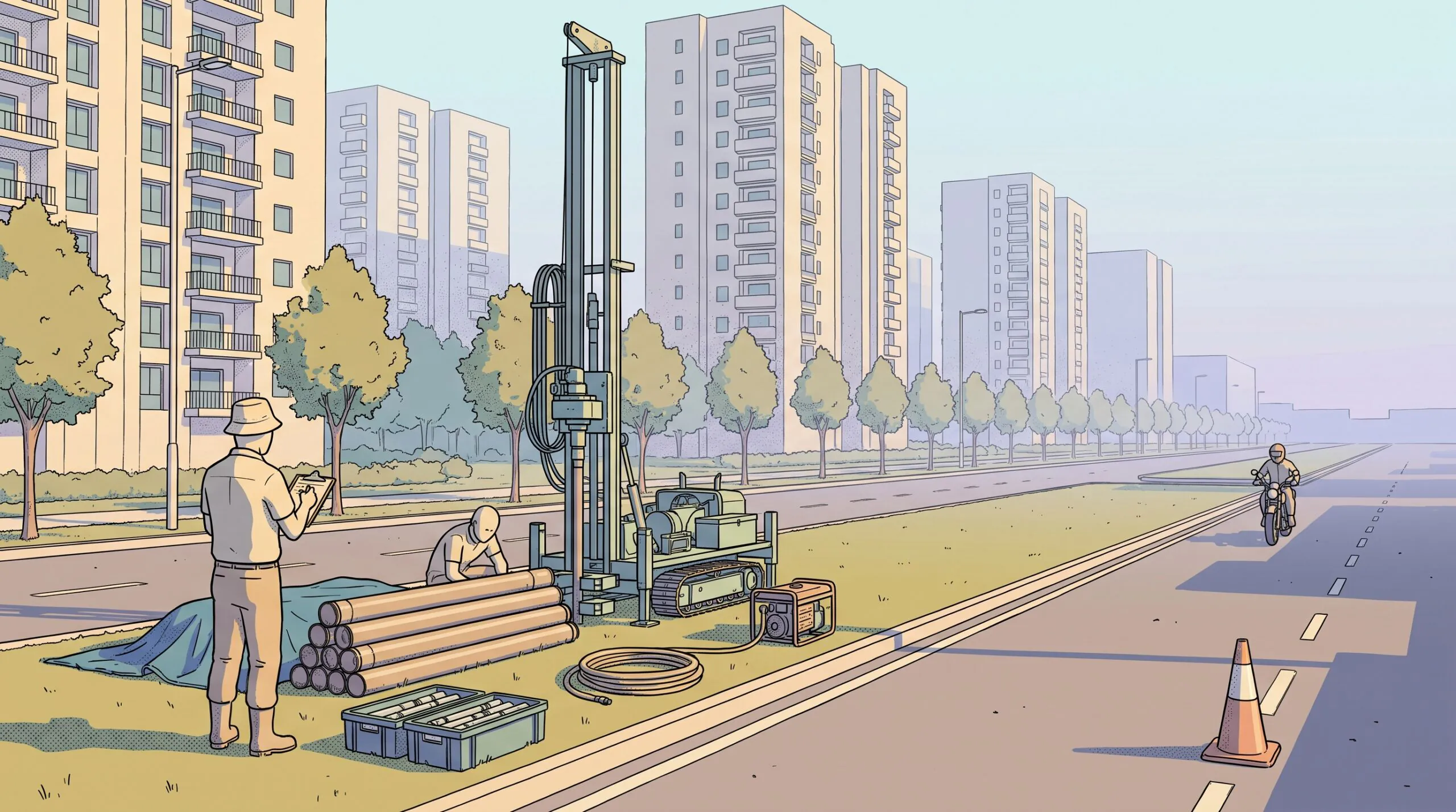
Some of that clay is being pulled from ground I walk over to buy durian. And the alignment they are testing was redrawn three months ago, which means the rigs outside my window are checking soil for a route that only recently became the route.
I have drawn a lot of imaginary metro networks. SimCity, Mini Metro, Citystate, thousands of hours in Cities: Skylines drawing lines nobody would ever ride. The thing the games never model is this bit – the years between the line existing on a map and the line existing, and the drilling crews who spend that time finding out whether the ground agrees with the plan.
Sài Gòn currently has 19.7 kilometers of metro and a 1,000 kilometers of intent. I would not bet on 2030. I would bet on the drilling.
